
Mapping the City
 |
|
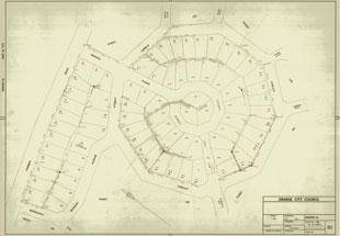
| Subdivision plan of the Westlea area showing Larella Circuit c1970s. | |
| Image courtesy: Orange City Council | |
Surveying, mapping and marking boundaries was the first step in making European style gardens in the Orange district. Land clearing followed surveying, felling trees, and the laborious task of grubbing out the stumps of the massive eucalypts that dotted the park-like landscape that eventually became Orange.
The first map of Orange was created after the village became a municipality in 1860. Orange was a small settlement of only about 400 people. The new village was laid out on a grid that set aside land for water reserves, a cricket ground, cemetery and a market.
Gradually the larger estates adjoining the centre of the town were subdivided into smaller estates and residential allotments. William Sampson subdivided Campdale and a portion of this estate became Duntryleague. Moulder let portions of his land east and south of the village reserve of Orange.
As Orange grew new areas were incorporated, including portions of Bletchington, Warrendine—referred to as the 'Potts Point' of Orange with its fine houses and gardens, Endsleigh and Glenroi. Parks, gardens and street plantings followed with subdivision and urban development.
Orange maintained its grid pattern until the 1970s with the development of the Westlea and Wiare subdivisions. These follow a 'garden suburb' design format of circuits and curving avenues, wide verges, no front fences, no hard pavements, underground utilities and buffering green belts separating the suburb from through traffic.